Frequently Asked Questions regarding property information available via the parcel viewer
How are property values shown on the property record card PDF?
The value is shown as subtotals. When there are multiple cards for an account you must add the land and building subtotals for each card in order to determine the total value.
Can I get a copy of a property record card on-line?
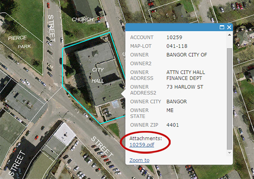
Copies of property record cards are available using the On-line Parcel Viewer. Use the search feature to locate the property you are interested in, click on the parcel, and the property information will be displayed. The property record card is shown as an attachment in PDF format. Once you have opened the attachment the card can be viewed, saved to your computer, or printed out. The below screenshot shows how to access the property record card:
Assessment data available via the On-Line Parcel Viewer includes Property Record Cards in PDF format
Is information updated throughout the year?
Assessment information in PDF format is fixed as of the assessment date. The information published on the website is not updated until the following year. More current information may be available at the Assessing Department.
Do you have phone numbers or email addresses for owners?
The Assessing Department does not have contact information beyond the mailing address for owners. The owner’s address available through the on-line parcel viewer, shown on the property record card in PDF format, is the address that the City uses to mail tax bills.
Does the property record card include a sketch of the buildings?
No. At this time sketch information is not available digitally. The Assessing Department hopes to have the sketches available digitally in the future, but there is no firm date available for this project. Sketches are available on hard-copy cards in the Assessing Department, and can be obtained by contacting the office. The measurement tool on the on-line parcel viewer can be used to estimate the size of improvements. When using the measurement tool, be aware that roof overhangs and building lean can exaggerate the size of an improvement.
I noticed something wrong on my property description. What should I do?
The Assessing Department is committed to maintaining complete and accurate records. If you find a problem with information about a property, please contact the Assessing Department. We will be happy to review any information you have, or schedule an inspection of the property.
What is the date of the aerial photography from the on-line parcel viewer?
The imagery was produced in May of 2019. There may be changes to the structures shown on the imagery over time. The aerial imagery will likely be updated every five years.